Garmin Alpha 50 Manuel du propriétaire - Page 3
Parcourez en ligne ou téléchargez le pdf Manuel du propriétaire pour {nom_de_la_catégorie} Garmin Alpha 50. Garmin Alpha 50 24 pages.
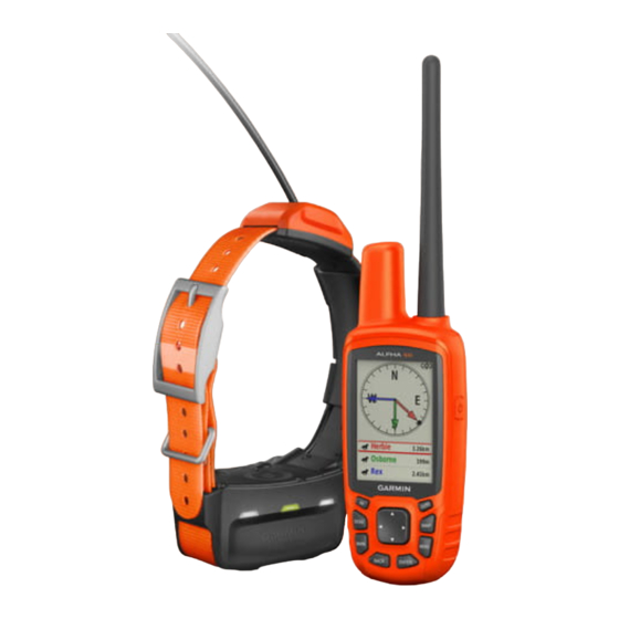
Table of Contents
Introduction.....................................................................1
Setting Up the System ................................................................ 1
Device Overviews ....................................................................... 1
Alpha 50 Handheld Device .................................................... 1
Keypad ................................................................................... 1
Dog Collar Device .................................................................. 1
Installing Batteries ...................................................................... 1
Charging the Dog Collar Device ................................................. 1
Turning On the Devices .............................................................. 2
Turning Off the Devices .............................................................. 2
Acquiring Satellite Signals .......................................................... 2
Adjusting the Backlight Brightness ............................................. 2
Fitting the Collar on Your Dog .................................................... 2
Using the On-Screen Keyboard .................................................. 2
Dog Tracking.................................................................. 2
Tracking Your Dog on the Map ................................................... 2
Navigating to Your Dog ............................................................... 2
Viewing Dog Status ................................................................ 3
Dog Status Icons .................................................................... 3
Location Alerts ............................................................................ 3
Setting a Geofence Alert ........................................................ 3
Setting a Radius Alert ............................................................ 3
Editing Location Alerts ........................................................... 3
Dog Information .......................................................................... 3
Hunt Metrics ........................................................................... 3
Resetting a Dog's Statistics and Track .................................. 3
Changing the Length of the Dog's Track ............................... 3
Changing a Dog Name .......................................................... 3
Changing the Color of the Dog's Track .................................. 3
Changing the Dog Type ......................................................... 3
Setting Dog Alerts .................................................................. 4
Removing a Dog .................................................................... 4
Pairing a Dog Collar to the Alpha Device ................................... 4
Adding a Dog Using the Track and Control Codes ................ 4
Assigning a Dog ID Manually ................................................. 4
Changing the Update Rate .................................................... 4
Communication with the Collar ................................................... 4
Tracking with BaseCamp™ BaseStation .................................... 4
Waypoints, Routes, and Tracks.................................... 4
Waypoints ................................................................................... 4
Marking Your Vehicle Location .............................................. 4
Marking Your Current Location .............................................. 5
Marking a Covey .................................................................... 5
Marking a Waypoint Using the Map ....................................... 5
Navigating to a Waypoint ....................................................... 5
Editing a Waypoint ................................................................. 5
Moving a Waypoint on the Map ............................................. 5
Repositioning a Waypoint to Your Current Location .............. 5
Increasing the Accuracy of a Waypoint Location ................... 5
Projecting a Waypoint ............................................................ 5
Deleting a Waypoint ............................................................... 5
Routes ........................................................................................ 5
Creating a Route .................................................................... 5
Navigating a Saved Route ..................................................... 5
Editing a Route ...................................................................... 5
Viewing the Active Route ....................................................... 5
Reversing a Route ................................................................. 5
Deleting a Route .................................................................... 6
Deleting All Routes ................................................................ 6
Tracks ......................................................................................... 6
Recording Track Logs ............................................................ 6
Viewing the Elevation Plot of a Track .................................... 6
Viewing Details about the Track ............................................ 6
Table of Contents
Saving the Current Track ....................................................... 6
Marking a Location on a Saved Track ................................... 6
Navigating to the Start of a Track .......................................... 6
Archiving a Track Manually .................................................... 6
Sending and Receiving Data Wirelessly ..................................... 6
Sharing Dog Information ........................................................ 6
Receiving Dog Information ..................................................... 6
Navigation....................................................................... 6
Map ............................................................................................. 6
Enabling the Map Data Fields ................................................ 7
Compass ..................................................................................... 7
Calibrating the Compass ........................................................ 7
Navigating with the Bearing Pointer ....................................... 7
Course Pointer ....................................................................... 7
Find Menu ................................................................................... 7
Finding a Waypoint by Name ................................................. 7
Navigating with Sight 'N Go ........................................................ 7
Viewing the Elevation Plot .......................................................... 7
Calibrating the Barometric Altimeter ...................................... 7
Navigating to a Point on the Plot ........................................... 7
Changing the Plot Type ......................................................... 7
Trip Computer ............................................................................. 7
Resetting the Trip Computer .................................................. 7
Applications.................................................................... 8
Setting a Proximity Alarm ........................................................... 8
Calculating the Size of an Area .................................................. 8
Viewing the Calendar and Almanacs .......................................... 8
Setting an Alarm ......................................................................... 8
Geocaches ..................................................................................8
Downloading Geocaches Using a Computer ......................... 8
Finding a Geocache ............................................................... 8
Filtering the Geocache List .................................................... 8
chirp™ .................................................................................... 8
Opening the Stopwatch .............................................................. 8
Satellite Page .............................................................................. 8
Changing the Satellite View ................................................... 8
Turning Off GPS .................................................................... 9
Simulating a Location ............................................................. 9
Disabling Dog Data Broadcast .................................................... 9
Enabling Bark Detection ............................................................. 9
Enabling Rescue Mode ............................................................... 9
VIRB® Remote ........................................................................... 9
Customizing Your Device.............................................. 9
Customizing the Main Menu ....................................................... 9
Customizing the Data Fields ....................................................... 9
Profiles ........................................................................................ 9
Creating a Custom Profile ...................................................... 9
Editing a Profile Name ........................................................... 9
Deleting a Profile .................................................................... 9
System Settings .......................................................................... 9
Dog Settings ............................................................................... 9
Display Settings ........................................................................ 10
Setting the Device Tones .......................................................... 10
Map Settings ............................................................................. 10
Advanced Map Settings ....................................................... 10
Tracks Settings ......................................................................... 10
Changing the Units of Measure ................................................ 10
Time Settings ............................................................................ 10
Position Format Settings ........................................................... 10
Heading Settings ...................................................................... 10
Altimeter Settings ...................................................................... 10
Geocaching Settings ................................................................. 11
Routing Settings ....................................................................... 11
Marine Map Settings ................................................................. 11
Setting up Marine Alarms ..................................................... 11
i