Blueprint Subsea ArtemisPRO 빠른 참조 매뉴얼 - 페이지 3
{카테고리_이름} Blueprint Subsea ArtemisPRO에 대한 빠른 참조 매뉴얼을 온라인으로 검색하거나 PDF를 다운로드하세요. Blueprint Subsea ArtemisPRO 4 페이지.
MISSION FILES & MARKERS
Markers are geographic locations such as waypoints (defining a swim
route), targets, hazards or other points of interest.
Mission Files contains lists of markers that are relevant to a dive.
Mission Files can be created on a PC using NavPoint or on the console.
"HOME"
23/04/2016
Power
15:45:01
Sonar
artemis
Navigation
pro
Vision
Diver
www.blueprintsubsea.com
v2.0.1234
Navigation Bubble
Provides guidance to the selected marker in the Status Bar:
> 90°
> 60°
> 30°
< 30°
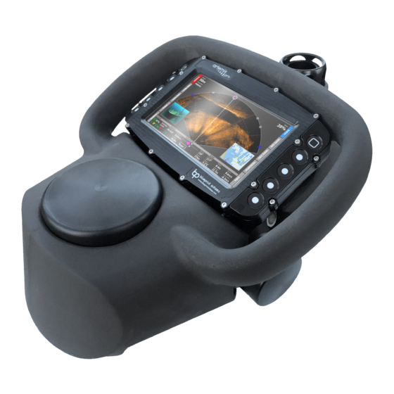
USING THE SONAR
Sonar Power
Power
Charge:
Estimated Life:
73%
04:18
Voltage:
Power Drain:
14.5V
26.1W
System Status:
Operating State
(Green = Working)
SONAR
DVL
FLOAT
CAMERA
Power:
Heading:
Depth:
217°
8.4m
Sonar Display
Range:
50m
Frequency:
750kHz
Range
Frequency
Low/High
Power:
Heading:
Depth:
217°
27.9m
Acoustic Shadows
Use the shadows cast by sound to
help identify targets:
Shallow Seabed
Angle
Long Acoustic
Shadow
T
Narrow
Distant
Acoustic
Target
Shadow
Mission Manager
Missions
Diver Training Area
Lake Investigation
Shallow Water Survey
Harbour Inspection
Artemis01234 2016-02-21 14:54:13
Artemis01234 2016-03-04 11:28:47
"MISSIONS"
Power:
Tools
Missions
or
Marker Manager
Markers
Markers
Dive Logs
4.
"MARKERS"
5. Waypoint 5
Start Dive
6. Waypoint 6
7. Waypoint 7
8. Waypoint 8
9. Target 1
10.
11. Slipway
12. Lock Gate
The marker to the le or right
Power:
of the current heading.
The diver should turn in the
direction shown.
Rotate to align the 'bubble' in
the centre of the bar.
The diver is on course for the
selected marker.
Power State (Red = Off)
Power Control
Sonar System:
ON
(On/Off)
Vision System:
OFF
Power Saving Mode
Power Mode:
LOW POWER
(Low, Normal, High)
LIGHT
Selected Marker:
Distance:
Altitude:
DiveLog:
374m
32.7m
Target 2
Gain:
20%
Gain
Image
Brightness
WAYPOINT 12
MARKER 4
MARKER 3
WAYPOINT 10
WAYPOINT 9
WAYPOINT 7
WAYPOINT 8
MARKER 2
WAYPOINT 6
Selected Marker:
Distance:
Altitude:
DiveLog:
374m
2.3m
Target 3
Steep
Seabed
Angle
Short
Acoustic
Shadow
T
Wide
Nearby
Acoustic
Target
Shadow
Current Mission
Filename:
Harbour Inspection
Created:
2016-01-18, 13:45:07
Markers:
14
Heading:
Depth:
Selected Marker:
Distance:
Altitude:
217°
8.4m
374m
32.7m
Target 3
Current Marker
Name:
Waypoint 4
Target 2
Position
54° 13' 54.273" N
-3° 2' 37.178" E
Depth:
3m
Type:
Target Marker
Target 2
Distane To Marker:
Bearing To Marker:
374m
124°
Heading:
Depth:
Selected Marker:
Distance:
Altitude:
217°
8.4m
374m
32.7m
Target 3
Marker Editor
Use up and down arrows to highlight
the field to edit and +10, +1, -1 and
-10 buttons to adjust the value.
Frequency
750kHz Low Frequency Mode
Shows targets up to 120m range
Horizontal 130° field-of-view
Used for searching avtivities.
1200kHz High Frequency Mode
Shows targets up to 40m range
Horizontal 80° field-of-view
Used for high detail inspection.
Gain
Controls the
brightness of the
sonar image
Seabed Coverage
A rule-of-thumb for 70% seabed coverage on the display is to maintain an altitude of 10% of
the sonar range above the seabed:
Altitude approx
10% of Range
Sonar Palettes
Obscured
The colour scheme of the display image can be selected using the
Target
Palettes option in the Sonar Settings menu:
Move the list selection
up and down
Use the highlighted
Mission File
The Marker Manager will
show markers from this
file.
Create a new
DiveLog:
Mission File
Use the highlighted
Marker as the navigation
destination
The Navigation Bubble provides guidance.
Edit Marker
Name:
Diver Added 2
Latitude:
DiveLog:
54°
13' 53 .
27"
N
Latitude:
003° 02' 31 .
18"
W
Depth:
3.0m
Type:
Diver Added Marker
Colour
Gold
Power:
Heading:
Depth:
23°
3.1m
Range &
Beam Pattern
Horizontal
High Frequency
Low Frequency
Vertical
Less Gain
Range (R)
approx 15°
70% Seabed Coverage
Selected Marker:
Distance:
Altitude:
DiveLog:
58m
4.9m
Diver Added 2
up to
up to
40m
120m
80°
130°
20°
12°
More Gain
Grey
Copper
Blue
Green