Garmin TREAD Instrukcja obsługi - Strona 15
Przeglądaj online lub pobierz pdf Instrukcja obsługi dla GPS Garmin TREAD. Garmin TREAD 38 stron.
Również dla Garmin TREAD: Instrukcja instalacji (14 strony)
2
Select
> Incidents.
3
Select an item in the list.
4
If there is more than one incident, use the arrows to view
additional incidents.
Customising the map
Customising the map layers
You can customise which data appears on the map, such as
topographic maps and BirdsEye imagery.
1
Select
> Map Display > Map Layers.
2
Select the tick box next to each layer you want to show on
the map.
Viewing the Public Lands Map Key
Public lands are colour-coded on the map to show who owns a
specific plot of land. For example, you can see if a plot of land is
privately owned or if it is part of a national park. You must
enable the public lands map layer to use this feature
(Customising the map layers, page
You can view the legend for these colours on the device.
Select
> Map Display > Map Layers >
Enabling Adventure Roads and Trails Map Layers
You can enable or disable map layers that display accessible or
inaccessible roads for different types of motor vehicles.
1
Select
> Map Display > Map Layers >
Roads & Trails.
2
Select a road or trail type.
Changing the map data field
1
From the map, select a data field.
NOTE: you cannot customise Speed.
2
Select a type of data to display.
Changing the Map Buttons
1
From the map, hold a map button.
2
Select an option:
• To replace a map button, select a map button and select a
map button to display.
• To remove a map button, select .
3
Select Save.
Changing the map perspective
1
Select
> Map Display > Driving Map View.
2
Select an option:
• Select Track Up to display the map in two dimensions (2-
D), with your direction of travel at the top.
• Select North Up to display the map in 2-D with North at
the top.
• Select 3-D to display the map in three dimensions.
Using the apps
Viewing the Owner's Manual on Your Device
You can view the complete owner's manual on the device
screen in many languages.
1
Select
> Owner's Manual.
The owner's manual appears in the same language as the
software text.
2
Select
to search the owner's manual (optional).
Music Player
The music player can play music or audio from these sources.
Using the apps
9).
> Public Lands.
> Adventure
• Music files stored on your Tread device.
• Bluetooth audio from a paired phone.
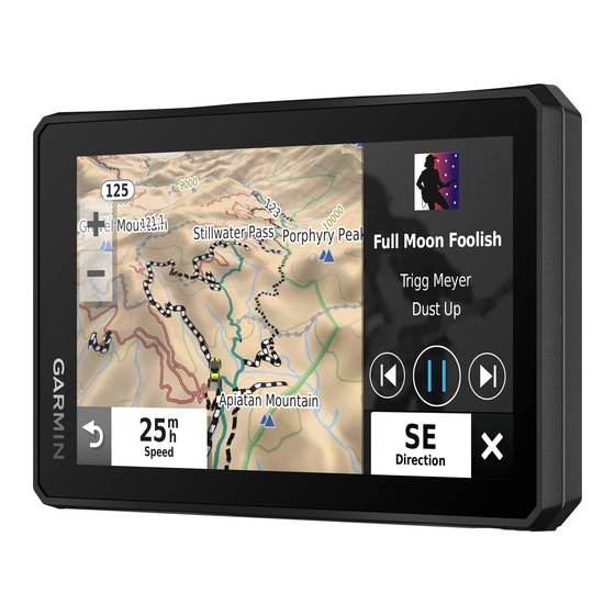
Adding the Music Player Tool to the Map
The music player map tool enables you to control the music
player from your map.
1
Open the map.
2
Select
> Music Player.
The music player controls appear on the map.
Changing the Media Source
You can change the source from which media is played on your
device.
1
Select
> Music Player.
2
Select the current media source
3
Select an available media source from the list.
BirdsEye Imagery
BirdsEye imagery provides downloadable, high-resolution map
imagery, including detailed satellite imagery and raster-based
topographical maps. You can download BirdsEye Satellite
Imagery directly to your device when it is connected to a Wi‑Fi
network.
Downloading BirdsEye Imagery
Before you can download BirdsEye imagery directly to your
device, you must connect to a wireless network
‑ Fi Network, page
Wi
23).
1
Select
> BirdsEye Direct.
2
Select .
3
Select an option:
• To download BirdsEye imagery files for a specific location
or area, select Location and select a category.
NOTE: the location defaults to your current location.
• To select an image quality option, select Detail.
• To define the size of the area to be shown in the
downloaded imagery files, select Height and enter a
distance from the selected location.
• To select where to save the downloaded imagery, select
Save to.
4
Select Download.
5
Enter a name for the downloaded imagery and select Done.
Trip planner
You can use the trip planner to create and save a trip, which you
can navigate later. This can be useful for planning a delivery
route, a vacation, or a road trip. You can edit a saved trip to
further customise it, including reordering locations, optimising
the order of stops, adding suggested attractions and adding
shaping points.
You can also use the trip planner to edit and save your active
route.
.
(Connecting to a
9