- ページ 20
アビオニクス・ディスプレイ Garmin G500のPDF マニュアルをオンラインで閲覧またはダウンロードできます。Garmin G500 40 ページ。 Primary flight and multifuction display system
Garmin G500 にも: クイック・リファレンス (2 ページ), 取扱説明書 (14 ページ)

Not all autopilot systems are approved for GPS vertical coupling; therefore
consult the AFMS for the GPS/SBAS system and/or the autopilot system.
Flight director commands on PFD 2 are repeated from PFD 1. When utilizing
the flight director display on PFD 2, ensure that the CDI source and BARO
settings on PFD 2 match those on PFD 1.
For installations where the GAD 43 provides attitude information to the
autopilot, the GAD 43 autopilot disconnect mechanism must be tested and
operational before flight using the autopilot. Refer to Section 4.6.9.
2.15 Terrain Proximity Function
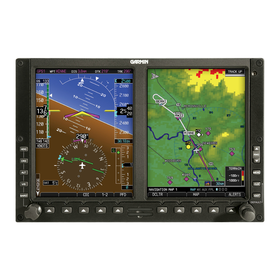
The G500 terrain configuration is indicated on the dedicated terrain page of the
MAP group. "TERRAIN PROXIMITY" will be displayed as the page title if
this function is configured. The G500 terrain and obstacle information appears
on the MFD display as red and yellow tiles or towers, and is depicted for
advisory only. Aircraft maneuvers and navigation must not be predicated upon
the use of the terrain display. Terrain unit alerts are advisory only and are not
equivalent to warnings provided by TAWS.
2.16 TAWS Annunciations on the PFD [from a Garmin navigator]
The G500 can display TAWS (Terrain Awareness and Warning System)
annunciations on the PFD if the G500 is interfaced to a Garmin navigator with
integrated TAWS. The required TAWS annunciations appear in the upper right
of the PFD. These annunciations include PULL UP (red), TERRAIN (yellow),
TERR N/A (white), TERR INHB (white). These annunciations are not relative
to the terrain displayed on the MFD or the yellow/red terrain shading of the
Synthetic Vision displayed on the PFD of the G500 system. Refer to the Garmin
navigator Airplane Flight Manual Supplement for proper pilot action and
information on these alerts.
TAWS alerts on the PFD of the G500 System are only displayed from the
GPS/TAWS navigator interfaced as GPS 1 and are displayed regardless of the
system 1-2 setting, which drives all other PFD and MFD data used by the G500.
2.17 Datalinked Weather Display (XM or GFDS weather)
Datalink weather data is provided by an optional GDL 69 (XM) or GSR 56
(GFDS) interface. The weather information display on the MFD of the G500 is
limited to supplemental use only and may not be used in lieu of an official
weather data source. Use of the datalink weather display for hazardous weather
(e.g thunderstorm) penetration is prohibited. The datalink weather display is
intended for use as an aid to situational awareness only.
2.18 Traffic Display
Traffic may be displayed on the G500 System when connected to an approved
optional TCAS, TAS, or TIS traffic device. These systems are capable of
providing traffic monitoring and alerting to the pilot. Traffic shown on the
display may or may not have traffic alerting available. The display of traffic is
an aid to visual acquisition and may not be utilized for aircraft maneuvering.
AFMS, GARMIN G500 PFD/MFD SYSTEM
190-01102-01 Rev. 9
FAA APPROVED
Page 20 of 40
